Opens the GPS log analyzer panel to analyze GPS tracklog files.
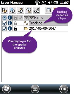
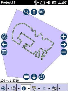
A GPS Tracklog and a polygon feature layer in the Layers panel and on the map view
The opened GPS Log analyzer panel
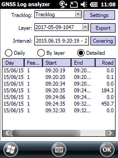
Tracklog: Select a GPS logfile (or a point feature layer) that stores logged GPS positions for processing. The default is "<nothing>".
![]() You have to delete and re add the tracklog file to the current map view after you changed the language of TopoLynx topoXplore.
You have to delete and re add the tracklog file to the current map view after you changed the language of TopoLynx topoXplore.
Layer: Select a reference layer to analyze the GPS logfile by a spatial analysis. The default is "<nothing>".
The spatial analysis works based on:
•Overlay analysis: can be used with a polygon feature layer (as overlay layer).
What GPS positions are within what parcels?
When GPS positions are within what parcels?
When GPS positions enter/leave what parcels?
What is the distance along the logged GPS positions within what parcels?
How long was made that distance within what parcels?
What is the average speed within what parcels?
What was the duration of the standing within what parcels?
•Proximity analysis: can be used with a point or polyline feature layer (as proximity reference layer). This analysis can identify logged GPS positions in the tracklog (or features in a layer) that are closest to an another feature of the proximity reference layer.
When GPS positions are closest to which point feature of the reference layer?
Interval: Set the time interval of the processing. Displays the duration of the GPS tracklog as default.
Settings - Opens the Logger tab on the Settings panel.
Export - Opens the Export list File dialog to export the results of the analysis as a report.
TXT - Exports the results by the selected current control (Daily, By Layer, Detailed) into a Tab limited Text file format.
XLS - Exports the results by the selected current control (Daily, By Layer, Detailed) into a Excel file format.
HTM - Exports the results for all current control (Daily, By Layer and Detailed) into a HTML file format.
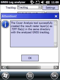
Covering Calculates the covers between paths of the GPS Tracklog and stores the results of the Cover Analysis in .TIF raster layers and .TXT text files to the overlayed polygon features of the reference layer.
Process of the Covering Analysis: enter the path width and the raster field resolution
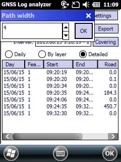
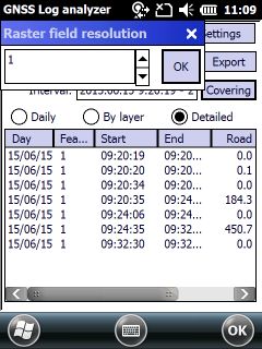
Path width: working width in current map unit.
Raster field resolution: size of one pixel in current map unit.
Result of an analyzed GPS tracklog for a parcel
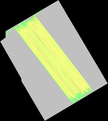
Results of the cover analysis for the same parcel
Cover Pixel Percent Area
0 564689 66.07 564689.00
1 62179 7.28 62179.00
2 221583 25.93 221583.00
3 6147 0.72 6147.00
4 38 0.00 38.00
5 2 0.00 2.00
Controls to the details of the report
Daily: Groups GPS positions by days.
By layer: Connects/groups GPS positions to the identified features of the reference layer.
Detailed: Shows the detailed processing of GPS positions. Separates motion and standing.
Meaning of the table columns
Day: Year, month, day of the grouped GPS positions.
Feature: Identifier of a feature that contains (polygon feature reference layer) or locates closest (point, polyline feature reference layer) the GPS positions. The data fields for identification can be selectable.
Start: Time of the start of the movement (entering the containing polygon feature).
End: Time of finish of the movement (leaving the containing polygon feature). Equal with the Start at the identified feature in case of proximity analysis (point or polyline feature reference layer).
Road: Total length of the movement (length within the containing polygon feature). Zero (0) at the identified feature in case of proximity analysis (point or polyline feature reference layer).
Move: Duration of the movement (duration within the containing polygon feature). Zero (0) at the identified feature in case of proximity analysis (point or polyline feature reference layer).
Speed: Average speed of the movement (average speed within the polygon feature).
Stand: Duration of the standing after the movement.