Opens the GNSS Status panel and activates the GNSS if it wasn't active.
The GNSS Status utility allows you to quickly see if the GNSS receiver is calculating a position from the currently visible GPS constellation.
The GPS Status panel
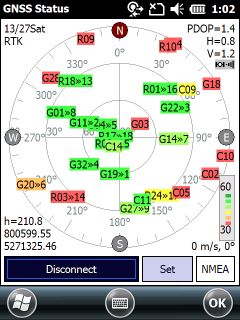
The GNSS Status panel displays the following, from left to right:
13/27: shows in this example that there are 13 satellites in use and there are 27 viewable satellites
RTK: shows the type of position; following other values are possible:
•"--- --" or "nofix" - Fixed position not available
•"Fix 2D" or "Fix 3D" - Fixed 2D or 3D autonomous solution
•"DGPS 3D" - Fixed differential GPS solution
•"FLRTK 3D" - Real Time Kinematic (RTK) floated solution
•"RTK 3D" - Real Time Kinematic (RTK) fixed solution
PDOP=1.4 - shows the current PDOP value
H=0.8 - shows the current HDOP value
V=1.2 - shows the current VDOP value
![]() satellite button: Shows the GPS activity. Displays when the GPS port can be opened (in case of using correct GPS port settings). Becomes animated when the GPS connection is activated.
satellite button: Shows the GPS activity. Displays when the GPS port can be opened (in case of using correct GPS port settings). Becomes animated when the GPS connection is activated.
![]() The current Easting, Northing GPS coordinate and the GPS status information (number of used/viewable GPS/GLO satellites, PDOP, solution type) displayed on the map view at the bottom right corner.
The current Easting, Northing GPS coordinate and the GPS status information (number of used/viewable GPS/GLO satellites, PDOP, solution type) displayed on the map view at the bottom right corner.
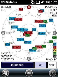
Skyplot - shows all the satellites currently in view/use. This window allows you to monitor Signal/Noise ratios (SNR) for received satellites. This information is shown as graphical to each satellite with a coloured number from red to green. Each satellite is identified by its Pseudo-Random Number (PRN), its azimuth and elevation angles on the Skyplot. The Skyplot will turn into the current calculated direction and shows the last direction and can be combined with the Navigate to Target function.
![]() - shows the satellite (PRN = 26) currently in use on channel 3
- shows the satellite (PRN = 26) currently in use on channel 3
![]() - shows the satellite (PRN = 19) currently in view
- shows the satellite (PRN = 19) currently in view
SBAS satellites marked with "D" beside the displayed PRN number
GLONASS satellites marked with "G" beside the displayed PRN number
![]() - SNR (Signal/Noise ratio) range to interpret the sign quality to the displayed satellite on the Skyplot (the greener the better). This legend is clickable, you can change the coloring of the satellites by the navigation system.
- SNR (Signal/Noise ratio) range to interpret the sign quality to the displayed satellite on the Skyplot (the greener the better). This legend is clickable, you can change the coloring of the satellites by the navigation system.
Satellites colored by satellite systems
h=210.6 - shows the calculated Height Above Ellipsoid of the current GPS position as default. Shows the calculated Height if the geoid undulation is available and can be used with the current GPS position.
800600.16 - shows the calculated Easting coordinates of the current GPS position in the selected projection
5271325.05 - shows the calculated Northing coordinates of the current GPS position in the selected projection
0 m/s, 0° - shows the calculated speed in the current speed unit and the last calculated heading
Connect / Disconnect - activates the GPS receiver (opens the GPS connection) / deactivates the GPS receiver (closes the GPS connection).
Set - opens the Settings panel > GPS tab to set / modify the currently used GPS related settings.
NMEA - displays the currently received NMEA sentences from the GPS device. Tap on the NMEA button again to close the NMEA window.
Displayed NMEA sentences in the NMEA window
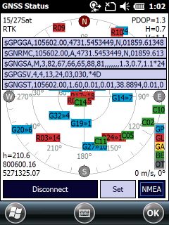
![]() The displayed NMEA sentences can be logged in the Logger tab of the Settings panel.
The displayed NMEA sentences can be logged in the Logger tab of the Settings panel.