The GNSS Resurveying designed for:
A.) Updating the geometry of an existing point, line or polygon feature to the selected attribute record with the GNSS menu > Survey panel using GPS
B.) Surveying geometry to a separate data table or TXT file with the GNSS menu > Survey panel by creating a vector feature layer using GPS
oseparate TXT file - > the result will be a MAP - TopoLynx layer with a TAB - TopoLynx file
oseparate DBF file -> the result will be a SHP - ESRI Shape layer with an SHX file, null-geometries are allowed
oseparate TAB file - > the result will be a MAP - TopoLynx layer to the existing TAB file, null-geometries are allowed
Using the GNSS Resurveying function
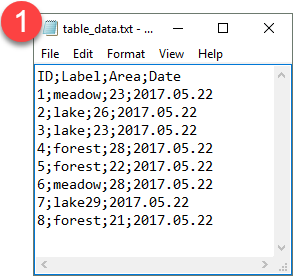
1.Let's say we have an data table (a TEXT file, a DBF or a TAB file) with important descriptive data but without any geographical information. If we know where they are on the field and additionally would like to link geometries to the records, GNSS Resurveying is the tool in our hand to do this painlessly.
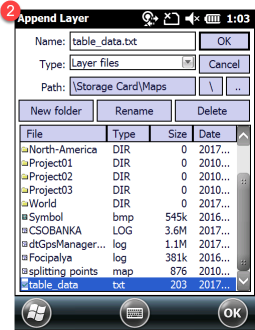
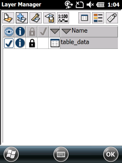
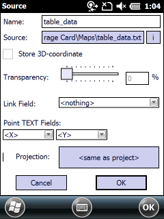
2.Add this TEXT file to the Layers panel with the ![]() Add Layer command
Add Layer command
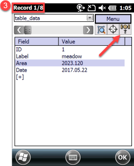
3.Open the Record panel to start the data capture. "Record 1/10" means the you have 10 records without geometry and you are at the first record, which is the current record. Use the scroll bar to find the proper record you want to start with then tap / click on the ![]() GNSS Resurveying button.
GNSS Resurveying button.
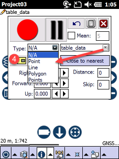
4.The GNSS Survey panel appears. Select feature type from the Type drop-down list, then you can start collecting GPS data with the RED button.
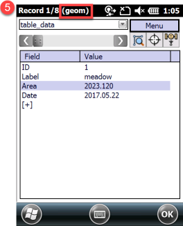
5.Once the geometry of the feature have been measured the GNSS Survey panel closes and the Record panel appears again with the same record where the GNSS Resurveying started.
6.Select the next record to link geometry or update the existing geometry of the selected feature. Then tap / click on the GNSS Resurveying button to continue.